

Wildfire looming over Squamish, B.C., reached within 40 metres of homes
By Canadian Press on June 11, 2025.
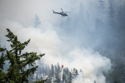
SQUAMISH — An out-of-control wildfire threatening neighbourhoods in Squamish, B.C., reached within 40 metres of some homes overnight as debris from burning trees fell near properties, the fire chief said Wednesday.
Aaron Foote, chief of Squamish Fire Rescue, told reporters that debris has been rolling down steep hillsides as local firefighters battle the blaze that’s looming over the community, next to the Sea to Sky Highway.
“Currently (the structures are) not at risk. We do have a good area of humidity,” he said. “We’ve been applying sprinkler systems throughout the past few days, and currently, they are not at risk.”
The Dryden Creek blaze was five hectares on Tuesday when the District of Squamish declared a local state of emergency and it has grown to more than 20 hectares, but Foote said the overnight growth was “minimal.”
Foote told the briefing that five helicopters are helping fight the fire that is burning in steep, forested terrain.
Marc Simpson with the BC Wildfire Service told the same briefing that about 30 personnel are on the ground to help and that number is increasing day by day.
“It will be a long, a multi-week process for some of these areas that our crews cannot access. We’re going to have to monitor in some areas and be very careful with our firefighter safety,” Simpson said
“We’re going to be dealing not only with the fire, but rolling debris, and oversized, rotten trees that we’ll have to deal with by falling, etc.”
The emergency declaration signed by Mayor Armand Hurford says the wildfire is threatening the neighbourhoods of Brackendale, Tantalus Road and Skyridge in the community about 60 kilometres north of Vancouver.
No evacuations have been ordered, but residents have been told to get ready to leave on short notice as firefighters work to protect homes and critical infrastructure.
The fire is highly visible from the Sea to Sky Highway and is believed to have been human caused.
RCMP Staff Sgt. Gareth Bradley said police are investigating how and where it started.
“We did hear some stories about people being on the trail,” he said.
“At this time, nobody has come forward to discuss that with us, so we’d like to open an opportunity for people that might have been out walking or hiking on the trail, to come in and talk to us about that.”
The Squamish fire is one of more than 93 wildfires burning throughout B.C., most of which are situated in the province’s northeast.
Although it has the most fires of any province or territory, British Columbia has so far been spared the worst impacts of Canada’s wildfires that have forced thousands from their homes in the Prairies.
The Canadian Interagency Forest Fire Centre reports 227 active fires across the country, with about half burning out of control.
There are 59 fires burning in Alberta and 23 in Ontario, where more than 1,400 people were evacuated from the Sandy Lake First Nation this week.
More than 10,000 people have been forced out of their homes due to a string of fires in Saskatchewan’s north, and Premier Scott Moe on Wednesday promised $500 in direct aid payment per person.
Most evacuees are from the Pelican Narrows and the La Ronge area, and those residents are either going back now or have been cleared to return later this week.
Manitoba and Saskatchewan have both declared states of emergency during one of their worst fire seasons in recent years.
About 21,000 people have been evacuated from Manitoba communities, including all 5,000 residents of Flin Flon and about 6,700 from Pimicikamak Cree Nation. There are 25 fires burning in Manitoba.
Christy Climenhaga with Environment Canada said the smoke from the Prairie fires is drifting into the United States, but the poorest air quality is in Alberta and Saskatchewan.
She said the Prairies may get relief this weekend.
“Smoke forecasting can be tricky, but that’s the wind pattern we’re expecting by Friday,” said Climenhaga.
Environment Canada issued special air quality statements on Wednesday due to wildfire smoke in B.C. covering Fort Nelson, Peace River, Williston and Stikine River and Spatsizi Plateau Wilderness Provincial Park, Howe Sound, and Inland Vancouver Island.
It says the smoke is causing or is expected to cause poor air quality and reduced visibility for the next 24 to 48 hours.
— With files from Ashley Joannou in Vancouver
This report by The Canadian Press was first published June 11, 2025.
Darryl Greer, The Canadian Press
33-32
