
Vancouver Island wildfire grows by more than half, rain is on the way
By Canadian Press on August 14, 2025.
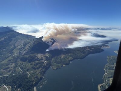
PORT ALBERNI — The wildfire that has triggered evacuation orders and alerts on south-central Vancouver Island has grown to more than 34 square kilometres, about 58 per cent larger than what it was the day before.
The BC Wildfire Service says the measurement of the Mount Underwood fire, 12 kilometres south of Port Alberni, B.C., may change again once crews can get a better look, either by helicopter or from the ground, as both are limited because of the thick smoke produced by the blaze.
The billowing smoke has prompted Environment Canada to expand an air quality advisory to the northern Gulf Islands and Sunshine Coast, with a bulletin from the agency saying smoke will be heaviest on eastern Vancouver Island, Texada Island and Powell River on the Sunshine Coast.
An update from the BC Wildfire Service said crews working the blaze overnight saw “moderate” fire behaviour, as cooler temperatures and higher humidity moved into the area.
“Southwest winds are expected today, with winds between eight and 15 km/h with gusts to 20,” the update issued Thursday said. “This will continue to push the fire in a northeasterly direction.”
Rain is expected to arrive in the region late Thursday, with between 15 and 40 mm forecast for the area of the fire, which spans more than 20 square kilometres.
The wildfire service says the moisture will help firefighting efforts, but the rain would have to be “significant” to have a meaningful impact over the longer term given the persistent drought that has gripped Vancouver Island.
In a video posted by the service late Wednesday, fire-behaviour analyst Ben Boghean said the challenge facing firefighters in addition to the steep terrain is an expected shift in wind direction as the cooler weather arrives.
“This is going to mean we are going to be turning what was the back of our fire into the head of our fire,” Boghean said. “There are a lot more fuels available to be pushed by this, and then moving up to the north and the northeast.
“Regardless of the amount of rain we have, because of the drought conditions out here, our fire is going be digging into these bigger logs, or heavier fuels we call them, and making it harder to actually be extinguished,” Boghean said.
The service also said crews are working to build a guard on the fire’s north flank, put out flames that cross the main road between Port Alberni and Bamfield, and secure firefighters’ access to the fire’s west flank.
The community of Bamfield has been without power since shortly after the fire was discovered on Monday, and the main road linking it with Port Alberni remains closed.
The Alberni-Clayoquot Regional District said in a post on its emergency operations Facebook page that the outage was expected to continue as BC Hydro personnel could not enter the area of the wildfire until it has been deemed safe.
Authorities are asking people who don’t live in Bamfield to avoid unnecessary travel to the community, which is a hub for hikers on the West Coast Trail.
The fire is one of about 90 active blazes across B.C., with fewer than 10 classified as burning out of control.
Port Alberni was experiencing “smoky skies” on Thursday, the regional district said.
“We’d like to remind people that, although it is smoky in Port Alberni, that is not necessarily an indication that the fire is moving closer to the city,” it said.
The fire’s rapid spread this week set off declarations of states of local emergency by the Alberni-Clayoquot Regional District, the City of Port Alberni and the Tseshaht First Nation.
Evacuation orders have been issued around parts of the fire, including for properties on the east side of the Alberni Inlet.
Alerts are also in effect for a Tseshaht reserve and properties at the southwest end of Port Alberni, where residents may be asked to evacuate on short notice.
The BC Wildfire Service said Wednesday that the fire was not threatening the communities of Port Alberni, Bamfield or Youbou.
This report by The Canadian Press was first published Aug. 14, 2025.
The Canadian Press
26-25
