Winter storms continue to hammer parts of Ontario, Quebec
By Canadian Press on December 30, 2025.
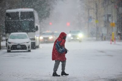
People in parts of Ontario and Quebec were dealing with more messy weather and in some cases blizzard-like conditions on Tuesday as storm fronts continue to hit the area.
Environment Canada warned of near-zero visibility at times in bursts of heavy snow as squalls and blowing snow were expected in parts of northern Ontario and west of Toronto.
Large snowfall amounts were expected in a wide swath of southwestern Ontario through Wednesday afternoon that could exceed 50 centimetres by Thursday morning in parts of Huron County and other regions.
Several highways around Timmins, Ont., remained closed Tuesday morning after Monday’s heavy snowfall in the region and ongoing blowing snow advisories. The city has also issued an extreme cold weather alert as wind chill temperatures are expected to drop to -28 C overnight.
A winter storm Monday brought freezing rain, blowing snow and strong winds across Eastern Canada that knocked out power to tens of thousands of people in Ontario. According to Hydro One utility’s outage map, thousands in the province were still without electricity as of Tuesday afternoon.
Meanwhile, Environment Canada says some areas northeast of Quebec City and into northern New Brunswick could see between 15 and 40 centimetres of snow along with high winds. In Quebec’s far north, blizzard conditions were expected to persist at least until midday on Thursday.
Much of Canada has been blasted with a number of weather systems over the last week, ranging from blizzards and cold snaps to freezing rain.
The weather has caused flight delays and cancellations at airports in Montréal, Halifax and elsewhere during the busy holiday travel period.
This report by The Canadian Press was first published Dec. 30, 2025.
The Canadian Press
13-12
