


Mild fall with fewer storms could end with abrupt wintry switch: Weather Network
By Canadian Press on September 10, 2025.
The dramatic start to Canada’s fall weather will give way to mild temperatures in the middle of the season, the Weather Network’s seasonal forecast suggests, but not before a possibly abrupt transition into early winter.
Record-breaking heat in British Columbia and early shots of cold weather in Central and Eastern Canada have already provided some “dramatic contrast” this month, said the network’s senior meteorologist Doug Gillham.
From mid-September through October, most of Canada is expected to “hit the pause button” on those temperature extremes, he said. Warmer-than-normal temperatures are expected to dominate with fewer storms through the heart of the season.
“It just means that in the temperature roller-coaster that’s normal with the season, that the milder periods will outweigh the periods of cooler weather,” said Gillham.
“That’ll give most Canadians some great stretches of weather to get outside and enjoy our fall foliage and enjoy outdoor activities.”
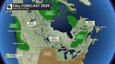
Those mild temperatures are expected to give way to a more active and changeable conditions in November, typical of late fall. Storms will be expected to bring precipitation levels up to near normal for most of Canada, according to The Weather Network’s seasonal forecast for the months of September, October and November.
Some areas could wind up a bit wetter than normal, primarily Northern Canada, the B.C. coast and a swath of northeastern Ontario through to central Quebec and Labrador, the forecast said.
“So, kind of a wild start, (then) we hit the pause button, get some mild quieter weather in the middle before we have a more typical finish to the season,” Gillham said.
The near-normal precipitation forecast will likely come as welcome news to parched parts of the northern Prairies where drought conditions have persisted through the summer, said Gillham.
Yet, the “biggest question mark” on the season’s precipitation forecast may be Atlantic Canada, Gillham said. Most of the region has been exceptionally dry and the forecast is calling for fewer fall storms there too.
“The wild card there though is the tropics,” said Gillham.
The second half of hurricane season could bring more activity in late September and early October, Gillham said. It looks like Florida will be the primary target and cooler waters in the North Atlantic Ocean compared to recent years could help weaken storms as they approach the Canadian coast, he said.
“But again, we’re not going to let our guard down in Atlantic Canada. We know it only takes one system to have a significant impact on the region,” he said.
After a chilly start to September, Ontario and Quebec are expected to see some warmer-than-normal temperatures before storm activity picks up again in November, the forecast suggests.
A similar story is shaping up in the Prairies. Shots of cold weather may interrupt otherwise extended periods of pleasant fall weather, the forecast says, but a flip to a colder and active pattern in November will set up a strong start to winter across the region, the forecast suggests.
Wildfire smoke will still be a concern for a few more weeks in Western Canada until the rainy season gets underway. While temperatures will start to drop off over the next couple of weeks, it will still be warmer than normal through the end of September and into early October, and any rain between now and then will likely be insufficient to significantly bring down the fire danger, Gillham said.
Meanwhile, the recent B.C. heat will give way to near-normal temperatures in that province as the season progresses, the forecast says. A typical number of fall storms and rainy days are in the forecast, but the coast could end up with above-normal precipitation because of the warm waters along the northern Pacific coast, Gillham said.
“I wouldn’t classify it as more stormy than normal but the storms that come have a higher risk to bring excessive rain,” he said.
“Hopefully we can avoid the flooding and just get the beneficial rain and alpine snow.”
Those warm waters in the northern Pacific Ocean are helping to push north the jet stream, the band of high-altitude winds circling the globe and acting as a boundary between cold arctic air and lower latitudes. The more northern jet stream position is part of what’s informing the forecast of a quieter and warmer heart of the fall season, Gillham said.
But “we can’t hold off the season forever,” Gillham said, and as the jet stream gradually shifts south, so too will the storm track.
“That’s why we expect more of an active November. More shots of arctic air will be showing up,” said Gillham.
The forecast is calling for near normal precipitation across most of Yukon and the Northwest Territories, with above-normal precipitation for much of Nunavut, Gillham said. Most of Northern Canada will see above-normal temperatures for the season, he said.
Climate change, driven by the burning of fossil fuels, has also shifted what meteorologists consider normal across Canada. The forecasts of above- or below-normal temperatures and precipitation are based on average conditions over roughly the past 30 years.
Yet, autumn average temperatures have increased by 2.4 degrees since 1948 across Canada, federal data suggests.
This report by The Canadian Press was first published Sept. 10, 2025.
Jordan Omstead, The Canadian Press
-29
