
Geologist shares the story of ‘The Scenic Geology of Alberta’
By Alejandra Pulido-Guzman - LETHBRIDGE HERALD on November 5, 2021.
 Herald photo by Alejandra Pulido-Guzman
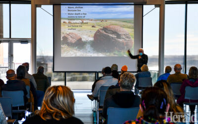
Geologist Dale Leckie speaks to an audience about the scenic geology of Alberta during a presentation Wednesday at the Galt Museum.
Herald photo by Alejandra Pulido-Guzman
Geologist Dale Leckie speaks to an audience about the scenic geology of Alberta during a presentation Wednesday at the Galt Museum.LETHBRIDGE HERALDapulido@lethbridgeherald.com
“The Scenic Geology of Alberta is the story of unbridled power, it’s a story of drama, glaciers and volcanoes long past and it’s a story of when banks failed,” says Dale Leckie.
The University of Calgary geologist spoke this week as part of the ‘The Galt presents…’ series, explaining how the landscape of Alberta’s most scenic sites evolved into what they are today.
Using photographs and paintings from two artists in his book “The Scenic Geology of Alberta: A Roadside Touring And Hiking Guide”, he blended storytelling with science incorporating the natural beauty of Alberta’s landscape with art and history. Giving people the opportunity to appreciate the landscapes from an artist perspective as well as from a geologist perspective.
“In the book I try and take people across the province to look at what I consider spectacular locations, places to look at, and visit and enjoy, and appreciate and understand how they got there,” said Leckie.
Leckie explained what happened in the town of Frank in 1903 and why the landslide occurred.
“Canada’s largest landslide, it came down in the middle of the night and destroyed half of the town of Frank where at least 90 people died, it dammed off the river, destroyed the railroad and destroyed the road,” said Leckie.
Leckie explained in further detail that the mountains had been folded and were weaken. Then they were thrusted and coal mining was going on at the base of the mountain which has said to have contributed to the landslide.
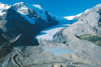
“This area has been glaciated several times, which has made for this really steep slope, all contributing factors to the Frank slide when banks failed,” said Leckie.
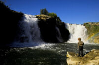
Leckie also told how the hoodoos from the Milk River area, in the Writing-on-Stone Provincial Park formed.
“The hoodoos formed by differential erosion. There were these cap rocks which are a little bit more resistant to erosion. The wind blow, the rain blows, the rain comes down and erodes the hoodoos. But those resistant cemented cap rocks are more resistant to erosion and we get more erosion down below to give the mystical forms that you see through the park,” said Leckie.
After the presentation was over, he answered some questions from the audience which included which was the most interesting thing he learned about a site.
“The most interesting thing would be Mud Butte’s neutral hills. Those glacially thrust features in the middle of the prairies. You are driving across the prairies and you just don’t expect these ice thrust ridges to be there up to 70-80 metres high. So what it gives you is great topography and it gives you some really beautiful colours in the middle of that farmland,” said Leckie.
Follow @APulidoHerald on Twitter
4-3
